2023-10-14 Solar Eclipse/locations: Difference between revisions
Nicole Sharp (talk | contribs) No edit summary |
Nicole Sharp (talk | contribs) |
||
| (58 intermediate revisions by the same user not shown) | |||
| Line 1: | Line 1: | ||
[[image:SE2023Oct14A.png|thumb|[Image.]  Globe showing the <u>[[2023-10-14 Solar Eclipse coordinates|Annular Solar Eclipse path]]</u> for 2023-10-14. <ref><code>[[commons:category:Solar eclipse of 2023 October 14]]</code></ref>]] | |||
To observe the <u>[[Annular Solar Eclipse of 2023-10-14]]</u> in the United States of America (USA), you want to be as far east as possible on the Path of Annularity in order to have the highest possible altitude angle at the time of eclipse maximum.  However, you also need to be in a location with clear (or mostly clear) skies and no (or very little) wind.  Corpus Christi (Texas) is the eastern terminus of the eclipse path in the USA but the weather in October for coastal Texas may not be favorable, which means getting further inland. <ref><u class="plainlinks"><code>https://www.nicolesharp.net/eclipse/2023-10-14.htm</code></u></ref> <ref><code>https://www.occultations.org/observing/software/occult/</code></ref> <ref><code>https://www.timeanddate.com/</code></ref> <ref><code>https://www.timeanddate.com/eclipse/solar/2023-october-14</code></ref> <ref><code>https://www.timeanddate.com/eclipse/in/usa/corpus-christi?iso=20231014</code></ref>  The next stop west along the eclipse centerline after Corpus Christi (Texas) is Hobbs (New Mexico). | |||
A major difference between a Total Solar Eclipse or Partial Solar Eclipse and an Annular Solar Eclipse is that in order to properly witness Solar annularity, you must be as close as possible to the eclipse centerline and not simply anywhere inside the eclipse path.  Any deviation from the eclipse centerline will cause Luna to appear off-axis and thus will not form a true Solar annulus.  Whereas during Solar totality, your geographic position inside the eclipse path determines the duration of totality but does not significantly affect the appearance of totality, unlike for annularity during an Annular Solar Eclipse.  This makes observing an Annular Solar Eclipse much more challenging than a Total Solar Eclipse since the number of available eclipse observation sites within the eclipse path is proportional to the square of the desired distance from the eclipse centerline. | |||
Additional considerations are that you need an unobstructed field of view in the direction of Sol (such as no buildings or trees in the way) and you will get a clearer view if there is vegetation or water in the azimuth direction of Sol (not sand, pavement, or buildings).  A Solar telescope should always be set up on grass (not pavement) if possible.  Ideally you want to avoid any urban areas since this can degrade seeing quality.  Your parking space should also be close enough to the observation site so that you have a direct line of sight between your telescope and your vehicle. | |||
== weather == | |||
=== 10-day weather forecasts === | |||
Remember that you should use GPS (Global Positioning System) coordinates to find observing sites and not rely on street addresses, especially since many parks and wilderness areas may have a postal address that is far away from the actual location. | * [https://www.weather.com/weather/tenday/l/730da308c2a8f24ad654e62954940bbc4c560aedb809d742e92e0cdfdd770bf7/ 10-Day Weather Forecast for Corpus Christi, Texas] | ||
* [https://www.weather.com/weather/tenday/l/3edd3f7385eb4702954c6d9503103c238fa1fe3d00428e00b2c3de33b9bc2b5a/ 10-Day Weather Forecast for Hobbs, New Mexico] | |||
* [https://www.weather.com/weather/tenday/l/bc2bceba4946ceac0b5da19c43815ac269b5fdedc51d3a8752800a156eff05a8/ 10-Day Weather Forecast for Albuquerque, New Mexico] | |||
* [https://www.weather.com/weather/tenday/l/e3ab07e5a999d29a06a674ee6dd654ba7917cfe31d6ca98945fbcbd71cc64bde/ 10-Day Weather Forecast for Rio Rancho, New Mexico] | |||
* [https://www.weather.com/weather/tenday/l/17e359905c5767a53d73171b85817cfd9d806be6b1cf5fe79eb9fe6eab622153/ 10-Day Weather Forecast for Nageezi, New Mexico] | |||
* [https://www.weather.com/weather/tenday/l/e5517d778218e1e932c47e560680fd73be730fa85f51d1082b544bb5d96cf0a4/ 10-Day Weather Forecast for Richfield, Utah] | |||
=== hourly weather forecasts === | |||
* [https://www.weather.com/weather/hourbyhour/l/730da308c2a8f24ad654e62954940bbc4c560aedb809d742e92e0cdfdd770bf7/ Hourly Weather Forecast for Corpus Christi, Texas] | |||
* [https://www.weather.com/weather/hourbyhour/l/3edd3f7385eb4702954c6d9503103c238fa1fe3d00428e00b2c3de33b9bc2b5a/ Hourly Weather Forecast for Hobbs, New Mexico] | |||
* [https://www.weather.com/weather/hourbyhour/l/bc2bceba4946ceac0b5da19c43815ac269b5fdedc51d3a8752800a156eff05a8/ Hourly Weather Forecast for Albuquerque, New Mexico] | |||
* [https://www.weather.com/weather/hourbyhour/l/e3ab07e5a999d29a06a674ee6dd654ba7917cfe31d6ca98945fbcbd71cc64bde/ Hourly Weather Forecast for Rio Rancho, New Mexico] | |||
* [https://www.weather.com/weather/hourbyhour/l/17e359905c5767a53d73171b85817cfd9d806be6b1cf5fe79eb9fe6eab622153/ Hourly Weather Forecast for Nageezi, New Mexico] | |||
* [https://www.weather.com/weather/hourbyhour/l/e5517d778218e1e932c47e560680fd73be730fa85f51d1082b544bb5d96cf0a4/ Hourly Weather Forecast for Richfield, Utah] | |||
== list == | |||
Locations listed here are within 2<sup>−16</sup> of a <u>[[Terran mean circumference]]</u> (0.6108 kilometers, 0.3795 miles, 668 yards, or 2004 feet) from the eclipse centerline which should provide the best possible Solar annulus. <ref><u><code>[[Terran mean circumference]]</code></u></ref>  All locations in Texas and New Mexico are listed, plus one additional location in Utah.  Locations are sorted by default from east to west in longitude, with no locations listed west of the easternmost location in Utah. | |||
<strong><u class="plainlinks">[https://www.nicolesharp.net/eclipse/2023-10-14.htm Click here to view the eclipse centerline with Google Maps.]</u></strong> | |||
Locations within 2<sup>−17</sup> of a Terran mean circumference (0.3054 kilometers, 0.1898 miles, 334 yards, or 1002 feet) from the eclipse centerline are listed in '''bold''' (19 locations), locations within 2<sup>−18</sup> of a Terran mean circumference (0.1527 kilometers, 0.09489 miles, 167 yards, or 501 feet) from the eclipse centerline are listed in '''<u>bold underline</u>''' (8 locations), and locations within 2<sup>−19</sup> of a Terran mean circumference (0.07635 kilometers, 0.04744 miles, 83.5 yards, or 250.5 feet) from the eclipse centerline are listed in '''<u class="d">bold double underline</u>''' (3 locations). | |||
The data provided here is intended as a general guideline only and may contain errors.  These locations were identified based on remote imagery from Google Maps and other than from the information that I can find available on the World Wide Web, I have no idea if they still exist or are publicly accessible. <ref><code>https://www.googlemaps.com/</code></ref>  You should have multiple locations selected in advance, scout the locations in person the day before the eclipse, and allow yourself enough time on the morning of the eclipse to change locations if necessary. | |||
Remember that you should use GPS (Global Positioning System) coordinates to find observing sites and not rely on street addresses, especially since many parks and wilderness areas may have a postal address that is far away from the actual location.  Addresses given in ''italics'' should definitely not be used for directions. | |||
<!--sse-->If you think that any locations should be removed from or added to this list, <u>[mailto:wiki@nicolesharp.net please let me know]</u>.  <!--/sse-->If you have actually visited any of these locations in person, I would love to get any feedback about their accessibility and usability for the Annular Solar Eclipse. | <!--sse-->If you think that any locations should be removed from or added to this list, <u>[mailto:wiki@nicolesharp.net please let me know]</u>.  <!--/sse-->If you have actually visited any of these locations in person, I would love to get any feedback about their accessibility and usability for the Annular Solar Eclipse. | ||
Latitudes and longitudes were identified using [https://www.googlemaps.com/ Google Maps].  Elevations are from the USGS (USA Geological Survey) [https://apps.nationalmap.gov/epqs/ Elevation Point Query Service].  Eclipse start times, times of eclipse maximum, eclipse end times, eclipse magnitudes (mag | Latitudes and longitudes were identified using [https://www.googlemaps.com/ Google Maps] in combination with [https://www.occultations.org/observing/software/occult/ Occult] from the [https://www.occultations.org/ International Occultation Timing Association (IOTA)].  Elevations are from the USGS (USA Geological Survey) [https://apps.nationalmap.gov/epqs/ Elevation Point Query Service]. <ref><code>https://apps.nationalmap.gov/epqs/</code></ref>  Eclipse start times, times of eclipse maximum, eclipse end times, eclipse magnitudes ("mag"), and [[wikipedia:altitude angles|altitude angles]] at maximum eclipse (expressed as [[wikipedia:airmasses|airmasses]] ["air"]) are from IOTA Occult. <ref><code>[[wikipedia:airmass]]</code></ref>  Average cloudiness (cl.) for October 14, average windspeed for October (expressed on the [[wikipedia:Beaufort wind force|Beaufort wind force]] [B] scale), average air temperature (te.) for October, and average air pressure (pr.) for October are from [https://www.timeanddate.com/ Time and Date Aksjeselskap]. <ref><code>[[wikipedia:Beaufort number]]</code></ref> | ||
Times are given in the local timezone (T) for each location. | |||
{| class="wikitable sortable" style="text-align: center;" | {| class="wikitable sortable" style="text-align: center;" | ||
| Line 26: | Line 54: | ||
! max | ! max | ||
! end | ! end | ||
! <abbr title="eclipse magnitude">mag | ! <abbr title="timezone hour offset from Zulu Time">T</abbr> | ||
! <abbr title="airmass"> | ! <abbr title="eclipse magnitude">mag</abbr> | ||
! <abbr title="cloudiness"> | ! <abbr title="airmass">air</abbr> | ||
! <abbr title="Beaufort wind force"> | ! <abbr title="cloudiness">cl.</abbr> | ||
! <abbr title="temperature"> | ! <abbr title="Beaufort wind force">B</abbr> | ||
! <abbr title="pressure"> | ! <abbr title="temperature">te.</abbr> | ||
! <abbr title=" | ! <abbr title="pressure">pr.</abbr> | ||
|- | |||
| <strong>[https://www.audubonoutdoorclub.com/conservation-sites/packery-channel-oak-motte-sanctuary/ Packery Channel Oak Motte Sanctuary]</strong> | |||
| [https://www.google.com/maps/place/27%C2%B037'44.8%22N+97%C2%B013'04.5%22W/ 14220 <abbr title="South">S.</abbr> Padre Island <abbr title="Drive">Dr.</abbr>, Corpus Christi, <abbr title="Texas">TX</abbr> 78404] | |||
| <code>27.629106993352558</code> | |||
| <code>-97.21791448668667</code> | |||
| 1.373965740 <abbr title="meters">m</abbr> | |||
| 10:26:51 | |||
| [https://www.timeanddate.com/eclipse/in/@27.62911,-97.21791?iso=20231014 11:58:52] | |||
| 13:38:55 | |||
| <code>-5</code> | |||
| 0.975 | |||
| <abbr title="ALT (altitude) 50 (degrees)">1.3</abbr><!-- 1.3054072893322786045931334929227 --> | |||
| 54% | |||
| <abbr title="8 kn (knots)">2.9</abbr><!-- 2.8939503848870861409230970337930 --> | |||
| 24<abbr title="degrees Celsius">°C</abbr> | |||
| 1016 <abbr title="millibars">mb</abbr> | |||
|- | |- | ||
| Packery Channel Park | | <strong>[https://www.nuecesco.com/home/components/facilitydirectory/facilitydirectory/282/ Packery Channel Nature Park]</strong> | ||
| 14218 Park | | [https://www.google.com/maps/place/27%C2%B037'35.1%22N+97%C2%B013'16.5%22W/ 14218 Park <abbr title="Road">Rd.</abbr> 22, Corpus Christi, TX 78418] | ||
| <code>27. | | <code>27.626424227586060</code> | ||
| <code>-97. | | <code>-97.22124179592429</code> | ||
| 2. | | 2.296695232 m | ||
| 10:26:51 | | 10:26:51 | ||
| 11:58:52 | | [https://www.timeanddate.com/eclipse/in/@27.62642,-97.22124?iso=20231014 11:58:52] | ||
| 13:38:55 | | 13:38:55 | ||
| <code>-5</code> | |||
| 0.975 | | 0.975 | ||
| <abbr title="ALT (altitude) 50 (degrees)">1.3</abbr><!-- 1.3054072893322786045931334929227 --> | | <abbr title="ALT (altitude) 50 (degrees)">1.3</abbr><!-- 1.3054072893322786045931334929227 --> | ||
| 54% | | 54% | ||
| <abbr title=" | | <abbr title="8 kn (knots)">2.9</abbr><!-- 2.8939503848870861409230970337930 --> | ||
| 24<abbr title="degrees Celsius">°C</abbr> | | 24<abbr title="degrees Celsius">°C</abbr> | ||
| 1016 <abbr title="millibars">mb</abbr> | | 1016 <abbr title="millibars">mb</abbr> | ||
|- | |- | ||
| Sarnia Park | | <strong>[https://www.cctexas.com/parks-recreation-facilities/ Sarnia Park]</strong> | ||
| 400A North Shoreline | | [https://www.google.com/maps/place/27%C2%B047'34.5%22N+97%C2%B023'18.2%22W/ 400A <abbr title="North">N.</abbr> Shoreline Dr., Corpus Christi, TX 78401] | ||
| <code>27. | | <code>27.792924914534540</code> | ||
| <code>-97. | | <code>-97.38837591377255</code> | ||
| 1. | | 1.483780622 m | ||
| 10:26:30 | | 10:26:30 | ||
| 11:58: | | [https://www.timeanddate.com/eclipse/in/@27.79292,-97.38838?iso=20231014 11:58:21] | ||
| 13:38:16 | | 13:38:16 | ||
| <code>-5</code> | |||
| 0.975 | | 0.975 | ||
| <abbr title="ALT 50">1.3</abbr><!-- 1.3054072893322786045931334929227 --> | | <abbr title="ALT 50">1.3</abbr><!-- 1.3054072893322786045931334929227 --> | ||
| Line 64: | Line 109: | ||
| 24°C | | 24°C | ||
| 1016 mb | | 1016 mb | ||
|- | |- | ||
| Sherrill Park | | <strong>[https://www.cctexas.com/parks-recreation-facilities/ Sherrill Park]</strong> | ||
| 222 | | [https://www.google.com/maps/place/27%C2%B047'27.6%22N+97%C2%B023'33.2%22W/ 222 S. Shoreline Dr., Corpus Christi, TX 78401] | ||
| <code>27.791001004482155</code> | | <code>27.791001004482155</code> | ||
| <code>-97.39255437129611</code> | | <code>-97.39255437129611</code> | ||
| 4.194799900 m | | 4.194799900 m | ||
| 10:26:30 | | 10:26:30 | ||
| 11:58:20 | | [https://www.timeanddate.com/eclipse/in/@27.79100,-97.39255?iso=20231014 11:58:20] | ||
| 13:38:16 | | 13:38:16 | ||
| <code>-5</code> | |||
| 0.975 | | 0.975 | ||
| <abbr title="ALT 50">1.3</abbr><!-- 1.3054072893322786045931334929227 --> | | <abbr title="ALT 50">1.3</abbr><!-- 1.3054072893322786045931334929227 --> | ||
| Line 80: | Line 125: | ||
| 24°C | | 24°C | ||
| 1016 mb | | 1016 mb | ||
|- | |- | ||
| Artesian Park | | <strong>[https://www.cctexas.com/parks-recreation-facilities/ Artesian Park]</strong> | ||
| 813 | | [https://www.google.com/maps/place/27%C2%B047'57.9%22N+97%C2%B023'41.1%22W/ 813 N. Chapparral <abbr title="Street">St.</abbr>, Corpus Christi, TX 78401] | ||
| <code>27. | | <code>27.799406697068680</code> | ||
| <code>-97. | | <code>-97.39475811576810</code> | ||
| 1. | | 1.426463366 m | ||
| 10:26:29 | | 10:26:29 | ||
| 11:58:19 | | [https://www.timeanddate.com/eclipse/in/@27.79941,-97.39476?iso=20231014 11:58:19] | ||
| 13:38:15 | | 13:38:15 | ||
| <code>-5</code> | |||
| 0.975 | | 0.975 | ||
| <abbr title="ALT 50">1.3</abbr><!-- 1.3054072893322786045931334929227 --> | | <abbr title="ALT 50">1.3</abbr><!-- 1.3054072893322786045931334929227 --> | ||
| Line 96: | Line 141: | ||
| 24°C | | 24°C | ||
| 1016 mb | | 1016 mb | ||
|- | |- | ||
| Spohn Park | | <strong>[https://www.cctexas.com/parks-recreation-facilities/ Spohn Park]</strong> | ||
| 213 | | [https://www.google.com/maps/place/27%C2%B047'38.9%22N+97%C2%B023'45.5%22W/ 213 N. Mesquite St., Corpus Christi, TX 78401] | ||
| <code>27.794126148686153</code> | | <code>27.794126148686153</code> | ||
| <code>-97.39597399238578</code> | | <code>-97.39597399238578</code> | ||
| 3.241936207 m | | 3.241936207 m | ||
| 10:26:30 | | 10:26:30 | ||
| 11:58:20 | | [https://www.timeanddate.com/eclipse/in/@27.79413,-97.39597?iso=20231014 11:58:20] | ||
| 13:38:15 | | 13:38:15 | ||
| <code>-5</code> | |||
| 0.975 | | 0.975 | ||
| <abbr title="ALT 50">1.3</abbr><!-- 1.3054072893322786045931334929227 --> | | <abbr title="ALT 50">1.3</abbr><!-- 1.3054072893322786045931334929227 --> | ||
| Line 112: | Line 157: | ||
| 24°C | | 24°C | ||
| 1016 mb | | 1016 mb | ||
|- | |- | ||
| Upper Broadway Park | | [https://www.cctexas.com/parks-recreation-facilities/ Upper Broadway Park] | ||
| 901 Leopard | | [https://www.google.com/maps/place/27%C2%B047'44.6%22N+97%C2%B024'00.8%22W/ 901 Leopard St., Corpus Christi, TX 78401] | ||
| <code>27.795710095997112</code> | | <code>27.795710095997112</code> | ||
| <code>-97.40023169807303</code> | | <code>-97.40023169807303</code> | ||
| 9.774136543 m | | 9.774136543 m | ||
| 10:26:29 | | 10:26:29 | ||
| 11:58:19 | | [https://www.timeanddate.com/eclipse/in/@27.79571,-97.40023?iso=20231014 11:58:19] | ||
| 13:38:15 | | 13:38:15 | ||
| <code>-5</code> | |||
| 0.975 | | 0.975 | ||
| <abbr title="ALT 50">1.3</abbr><!-- 1.3054072893322786045931334929227 --> | | <abbr title="ALT 50">1.3</abbr><!-- 1.3054072893322786045931334929227 --> | ||
| Line 128: | Line 173: | ||
| 24°C | | 24°C | ||
| 1016 mb | | 1016 mb | ||
|- | |- | ||
| Washington Park | | [https://www.hobbsnm.org/parks.html#washington1 Washington Park] | ||
| 520 | | [https://www.google.com/maps/place/32%C2%B041'42.5%22N+103%C2%B007'18.8%22W/ 520 S. Fourth St., Hobbs, <abbr title="New Mexico">NM</abbr> 88240] | ||
| <code>32.695132402803730</code> | | <code>32.695132402803730</code> | ||
| <code>-103.12189621057546</code> | | <code>-103.12189621057546</code> | ||
| 1098.750366211 m | | 1098.750366211 m | ||
| 09:17:09 | | 09:17:09 | ||
| 10:43:41 | | [https://www.timeanddate.com/eclipse/in/@32.69513,-103.12190?iso=20231014 10:43:41] | ||
| 12:18:57 | | 12:18:57 | ||
| <code>-6</code> | |||
| 0.974 | | 0.974 | ||
| <abbr title="ALT 41">1.5</abbr><!-- 1.5242530867058142423210210580816 --> | | <abbr title="ALT 41">1.5</abbr><!-- 1.5242530867058142423210210580816 --> | ||
| Line 144: | Line 189: | ||
| 17°C | | 17°C | ||
| 1016 mb | | 1016 mb | ||
|- | |- | ||
| King Soccerplex | | <strong><em class="u">[https://www.hobbsnm.org/parks.html#mlk King Soccerplex]</em></strong> | ||
| 1409 | | [https://www.google.com/maps/place/32%C2%B041'21.4%22N+103%C2%B007'31.2%22W/ 1409 S. Dal Paso St., Hobbs, NM 88240] | ||
| <code>32. | | <code>32.689280029909156</code> | ||
| <code>-103. | | <code>-103.12532471201577</code> | ||
| | | 1098.384399414 m | ||
| 09:17:09 | | 09:17:09 | ||
| 10:43:41 | | [https://www.timeanddate.com/eclipse/in/@32.68928,-103.12532?iso=20231014 10:43:41] | ||
| 12:18:57 | | 12:18:57 | ||
| <code>-6</code> | |||
| 0.974 | | 0.974 | ||
| <abbr title="ALT 41">1.5</abbr><!-- 1.5242530867058142423210210580816 --> | | <abbr title="ALT 41">1.5</abbr><!-- 1.5242530867058142423210210580816 --> | ||
| Line 160: | Line 205: | ||
| 17°C | | 17°C | ||
| 1016 mb | | 1016 mb | ||
|- | |- | ||
| Humble Park | | <strong>[https://www.hobbsnm.org/parks.html#humble Humble Park]</strong> | ||
| 820 | | [https://www.google.com/maps/place/32%C2%B042'30.2%22N+103%C2%B008'39.2%22W/ 820 N. Grimes St., Hobbs, NM 88240] | ||
| <code>32. | | <code>32.708390997363520</code> | ||
| <code>-103. | | <code>-103.14422018415978</code> | ||
| 1108. | | 1108.691162109 m | ||
| 09:17:07 | | 09:17:07 | ||
| 10:43:38 | | [https://www.timeanddate.com/eclipse/in/@32.70839,-103.14422?iso=20231014 10:43:38] | ||
| 12:18:53 | | 12:18:53 | ||
| <code>-6</code> | |||
| 0.974 | | 0.974 | ||
| <abbr title="ALT 41">1.5</abbr><!-- 1.5242530867058142423210210580816 --> | | <abbr title="ALT 41">1.5</abbr><!-- 1.5242530867058142423210210580816 --> | ||
| Line 176: | Line 221: | ||
| 17°C | | 17°C | ||
| 1016 mb | | 1016 mb | ||
|- | |- | ||
| Bensing Park | | <strong><em class="u">[https://jef.hobbsschools.net/ Jefferson Elementary School]</em></strong> | ||
| 1401 | | [https://www.google.com/maps/place/32%C2%B042'26.2%22N+103%C2%B008'57.1%22W/ 1200 <abbr title="West">W.</abbr> Park, Hobbs, NM 88240] | ||
| <code>32. | | <code>32.707276046843940</code> | ||
| <code>-103. | | <code>-103.14919783054361</code> | ||
| | | 1109.793945313 m | ||
| 09:17:07 | |||
| [https://www.timeanddate.com/eclipse/in/@32.70715,-103.15001?iso=20231014 10:43:38] | |||
| 12:18:52 | |||
| <code>-6</code> | |||
| 0.974 | |||
| <abbr title="ALT 41">1.5</abbr><!-- 1.5242530867058142423210210580816 --> | |||
| 32% | |||
| <abbr title="9 kn">3.1</abbr><!-- 3.1303490243207693187273883624566 --> | |||
| 17°C | |||
| 1016 mb | |||
|- | |||
| [https://www.hobbsnm.org/parks.html#bensing Bensing Park] | |||
| [https://www.google.com/maps/place/32%C2%B042'26.4%22N+103%C2%B009'07.0%22W/ 1401 W. Clinton St., Hobbs, NM 88240] | |||
| <code>32.707339411317975</code> | |||
| <code>-103.15193967651592</code> | |||
| 1110.165893555 m | |||
| 09:17:07 | | 09:17:07 | ||
| 10:43: | | [https://www.timeanddate.com/eclipse/in/@32.70734,-103.15194?iso=20231014 10:43:37] | ||
| 12:18:52 | | 12:18:52 | ||
| <code>-6</code> | |||
| 0.974 | | 0.974 | ||
| <abbr title="ALT 41">1.5</abbr><!-- 1.5242530867058142423210210580816 --> | | <abbr title="ALT 41">1.5</abbr><!-- 1.5242530867058142423210210580816 --> | ||
| Line 192: | Line 253: | ||
| 17°C | | 17°C | ||
| 1016 mb | | 1016 mb | ||
|- | |- | ||
| Three Gun Trailhead | | <strong>[https://fs.usda.gov/recarea/cibola/recarea/?recid=64606 Three Gun Trailhead]</strong> | ||
| 2113 Osuna | | <del class="i">[https://www.google.com/maps/place/35%C2%B004'35.3%22N+106%C2%B026'39.0%22W/ 2113 Osuna Rd. <abbr title="Northeast">NE</abbr>, Albuquerque, NM 87113]</del> | ||
| <code>35.076468878467640</code> | | <code>35.076468878467640</code> | ||
| <code>-106.44417450199971</code> | | <code>-106.44417450199971</code> | ||
| 1927.192138672 m | | 1927.192138672 m | ||
| 09:13:23 | | 09:13:23 | ||
| 10:37:13 | | [https://www.timeanddate.com/eclipse/in/@35.07647,-106.44417?iso=20231014 10:37:13] | ||
| 12:09:49 | | 12:09:49 | ||
| <code>-6</code> | |||
| 0.974 | | 0.974 | ||
| <abbr title="ALT 36">1.7</abbr><!-- 1.7013016167040798643630809941260 --> | | <abbr title="ALT 36">1.7</abbr><!-- 1.7013016167040798643630809941260 --> | ||
| Line 208: | Line 269: | ||
| 15°C | | 15°C | ||
| 1015 mb | | 1015 mb | ||
|- | |- | ||
| Embudo Trailhead | | <strong><em class="u">[https://fs.usda.gov/recarea/cibola/recarea/?recid=64214 Embudo Trailhead]</em></strong> | ||
| 2113 Osuna | | <del class="i">[https://www.google.com/maps/place/35%C2%B005'56.5%22N+106%C2%B028'47.2%22W/ 2113 Osuna Rd. NE, Albuquerque, NM 87113]</del> | ||
| <code>35.099015280469736</code> | | <code>35.099015280469736</code> | ||
| <code>-106.47977064544932</code> | | <code>-106.47977064544932</code> | ||
| 1883.783081055 m | | 1883.783081055 m | ||
| 09:13:21 | | 09:13:21 | ||
| 10:37:09 | | [https://www.timeanddate.com/eclipse/in/@35.09902,-106.47977?iso=20231014 10:37:09] | ||
| 12:09:43 | | 12:09:43 | ||
| <code>-6</code> | |||
| 0.974 | | 0.974 | ||
| <abbr title="ALT 36">1.7</abbr><!-- 1.7013016167040798643630809941260 --> | | <abbr title="ALT 36">1.7</abbr><!-- 1.7013016167040798643630809941260 --> | ||
| Line 224: | Line 285: | ||
| 15°C | | 15°C | ||
| 1015 mb | | 1015 mb | ||
|- | |- | ||
| Menaul Trailhead | | <strong>[https://www.cabq.gov/parksandrecreation/open-space/lands/sandia-foothills-open-space/ Menaul Trailhead]</strong> | ||
| | | <del class="i">[https://www.google.com/maps/place/35%C2%B006'17.8%22N+106%C2%B029'18.0%22W/ 3615 Los Picaros Rd. <abbr title="Southeast">SE</abbr>, Albuquerque, NM 87105]</del> | ||
| <code>35.104931742101790</code> | | <code>35.104931742101790</code> | ||
| <code>-106.48832607476871</code> | | <code>-106.48832607476871</code> | ||
| 1826.338378906 m | | 1826.338378906 m | ||
| 09:13:21 | | 09:13:21 | ||
| 10:37:09 | | [https://www.timeanddate.com/eclipse/in/@35.10493,-106.48833?iso=20231014 10:37:09] | ||
| 12:09:42 | | 12:09:42 | ||
| <code>-6</code> | |||
| 0.974 | | 0.974 | ||
| <abbr title="ALT 36">1.7</abbr><!-- 1.7013016167040798643630809941260 --> | | <abbr title="ALT 36">1.7</abbr><!-- 1.7013016167040798643630809941260 --> | ||
| Line 240: | Line 301: | ||
| 15°C | | 15°C | ||
| 1015 mb | | 1015 mb | ||
|- | |- | ||
| Holiday Park | | [https://www.cabq.gov/family/crei/community-centers/holiday-park-community-center/ Holiday Park] | ||
| 11710 Comanche | | [https://www.google.com/maps/place/35%C2%B007'23.4%22N+106%C2%B030'30.0%22W/ 11710 Comanche Rd. NE, Albuquerque, NM 87111] | ||
| <code>35.123171939684750</code> | | <code>35.123171939684750</code> | ||
| <code>-106.50832103164810</code> | | <code>-106.50832103164810</code> | ||
| 1746.963500977 m | | 1746.963500977 m | ||
| 09:13:20 | | 09:13:20 | ||
| 10:37:06 | | [https://www.timeanddate.com/eclipse/in/@35.12317,-106.50832?iso=20231014 10:37:06] | ||
| 12:09:39 | | 12:09:39 | ||
| <code>-6</code> | |||
| 0.974 | | 0.974 | ||
| <abbr title="ALT 36">1.7</abbr><!-- 1.7013016167040798643630809941260 --> | | <abbr title="ALT 36">1.7</abbr><!-- 1.7013016167040798643630809941260 --> | ||
| Line 256: | Line 317: | ||
| 15°C | | 15°C | ||
| 1015 mb | | 1015 mb | ||
|- | |- | ||
| Haynes Park | | <strong>[https://www.rrnm.gov/1045/ Haynes Park]</strong> | ||
| 2006 Grande | | [https://www.google.com/maps/place/35%C2%B013'19.4%22N+106%C2%B039'47.4%22W/ 2006 Grande <abbr title="Boulevard">Blvd.</abbr> SE, Rio Rancho, NM 87144] | ||
| <code>35.222059979304080</code> | | <code>35.222059979304080</code> | ||
| <code>-106.66316591794453</code> | | <code>-106.66316591794453</code> | ||
| 1595.085327148 m | | 1595.085327148 m | ||
| 09:13:11 | | 09:13:11 | ||
| 10:36:51 | | [https://www.timeanddate.com/eclipse/in/@35.22206,-106.66317?iso=20231014 10:36:51] | ||
| 12:09:16 | | 12:09:16 | ||
| <code>-6</code> | |||
| 0.974 | | 0.974 | ||
| <abbr title="ALT 36">1.7</abbr><!-- 1.7013016167040798643630809941260 --> | | <abbr title="ALT 36">1.7</abbr><!-- 1.7013016167040798643630809941260 --> | ||
| Line 272: | Line 333: | ||
| 15°C | | 15°C | ||
| 1015 mb | | 1015 mb | ||
|- | |- | ||
| Chianti Park | | <strong><u class="d">[https://www.rrnm.gov/1951/ Chianti Park]</u></strong> | ||
| 1210 Chianti | | [https://www.google.com/maps/place/35%C2%B013'58.6%22N+106%C2%B040'52.5%22W/ 1210 Chianti Rd. SE, Rio Rancho, NM 87144] | ||
| <code>35. | | <code>35.232948599933830</code> | ||
| <code>-106. | | <code>-106.68123588833546</code> | ||
| | | 1617.083740234 m | ||
| 09:13:10 | | 09:13:10 | ||
| 10:36:49 | | [https://www.timeanddate.com/eclipse/in/@35.23295,-106.68124?iso=20231014 10:36:49] | ||
| 12:09:13 | | 12:09:13 | ||
| <code>-6</code> | |||
| 0.974 | | 0.974 | ||
| <abbr title="ALT 36">1.7</abbr><!-- 1.7013016167040798643630809941260 --> | | <abbr title="ALT 36">1.7</abbr><!-- 1.7013016167040798643630809941260 --> | ||
| Line 288: | Line 349: | ||
| 15°C | | 15°C | ||
| 1015 mb | | 1015 mb | ||
|- | |- | ||
| Cabezon Park | | [https://www.rrnm.gov/1033/ Cabezon Park] | ||
| | | [https://www.google.com/maps/place/35%C2%B013'54.1%22N+106%C2%B041'22.0%22W/ 2305 Cabezon Blvd. SE, Rio Rancho, NM 87144] | ||
| <code>35.231706034043285</code> | | <code>35.231706034043285</code> | ||
| <code>-106.68944544040455</code> | | <code>-106.68944544040455</code> | ||
| 1617.995361328 m | | 1617.995361328 m | ||
| 09:13:10 | | 09:13:10 | ||
| 10:36:48 | | [https://www.timeanddate.com/eclipse/in/@35.23171,-106.68945?iso=20231014 10:36:48] | ||
| 12:09:12 | | 12:09:12 | ||
| <code>-6</code> | |||
| 0.974 | | 0.974 | ||
| <abbr title="ALT 36">1.7</abbr><!-- 1.7013016167040798643630809941260 --> | | <abbr title="ALT 36">1.7</abbr><!-- 1.7013016167040798643630809941260 --> | ||
| Line 304: | Line 365: | ||
| 15°C | | 15°C | ||
| 1015 mb | | 1015 mb | ||
|- | |- | ||
| Western Winds Park | | [https://www.rrnm.gov/1077/ Western Winds Park] | ||
| 2260 Zaragoza | | [https://www.google.com/maps/place/35%C2%B014'43.2%22N+106%C2%B041'27.5%22W/ 2260 Zaragoza Rd. SE, Rio Rancho, NM 87144] | ||
| <code>35.245321265835486</code> | | <code>35.245321265835486</code> | ||
| <code>-106.69098172286776</code> | | <code>-106.69098172286776</code> | ||
| 1650.114257813 m | | 1650.114257813 m | ||
| 09:13:09 | | 09:13:09 | ||
| 10:36:48 | | [https://www.timeanddate.com/eclipse/in/@35.24532,-106.69098?iso=20231014 10:36:48] | ||
| 12:09:11 | | 12:09:11 | ||
| <code>-6</code> | |||
| 0.974 | | 0.974 | ||
| <abbr title="ALT 36">1.7</abbr><!-- 1.7013016167040798643630809941260 --> | | <abbr title="ALT 36">1.7</abbr><!-- 1.7013016167040798643630809941260 --> | ||
| Line 320: | Line 381: | ||
| 15°C | | 15°C | ||
| 1015 mb | | 1015 mb | ||
|- | |- | ||
| Star Heights Park | | <strong><u class="d">[https://www.rrnm.gov/1068/ Star Heights Park]</u></strong> | ||
| 800 Polaris | | [https://www.google.com/maps/place/35%C2%B014'48.7%22N+106%C2%B042'11.2%22W/ 800 Polaris Blvd. SE, Rio Rancho, NM 87144] | ||
| <code>35.246861788085420</code> | | <code>35.246861788085420</code> | ||
| <code>-106.70309738645146</code> | | <code>-106.70309738645146</code> | ||
| 1669.708618164 m | | 1669.708618164 m | ||
| 09:13:09 | | 09:13:09 | ||
| 10:36:47 | | [https://www.timeanddate.com/eclipse/in/@35.24686,-106.70310?iso=20231014 10:36:47] | ||
| 12:09:10 | | 12:09:10 | ||
| <code>-6</code> | |||
| 0.974 | | 0.974 | ||
| <abbr title="ALT 36">1.7</abbr><!-- 1.7013016167040798643630809941260 --> | | <abbr title="ALT 36">1.7</abbr><!-- 1.7013016167040798643630809941260 --> | ||
| Line 336: | Line 397: | ||
| 15°C | | 15°C | ||
| 1015 mb | | 1015 mb | ||
|- | |- | ||
| Sugar Park | | <strong><em class="u">[https://www.rrnm.gov/1070/ Sugar Park]</em></strong> | ||
| 500 Sugar | | [https://www.google.com/maps/place/35%C2%B015'08.5%22N+106%C2%B042'33.0%22W/ 500 Sugar Rd. NE, Rio Rancho, NM 87144] | ||
| <code>35. | | <code>35.252347780215445</code> | ||
| <code>-106. | | <code>-106.70916693777448</code> | ||
| 1698. | | 1698.502319336 m | ||
| 09:13:08 | | 09:13:08 | ||
| 10:36:46 | | [https://www.timeanddate.com/eclipse/in/@35.25235,-106.70917?iso=20231014 10:36:46] | ||
| 12:09:09 | | 12:09:09 | ||
| <code>-6</code> | |||
| 0.974 | | 0.974 | ||
| <abbr title="ALT 36">1.7</abbr><!-- 1.7013016167040798643630809941260 --> | | <abbr title="ALT 36">1.7</abbr><!-- 1.7013016167040798643630809941260 --> | ||
| Line 352: | Line 413: | ||
| 15°C | | 15°C | ||
| 1015 mb | | 1015 mb | ||
| | |- | ||
| <strong><u class="d">[https://www.nps.gov/chcu/ Chaco Culture National Historical Park]</u></strong> | |||
| <del class="i">[https://www.google.com/maps/place/36%C2%B001'49.8%22N+107%C2%B054'18.6%22W/ 11577 USA <abbr title="Highway">Hwy.</abbr> 550, Nageezi, NM 87037]</del> | |||
| <code>36.030512129387496</code> | |||
| <code>-107.90517899441724</code> | |||
| 1889.114013672 m | |||
| 09:12:03 | |||
| [https://www.timeanddate.com/eclipse/in/@36.03051,-107.90518?iso=20231014 10:34:46] | |||
| 12:06:13 | |||
| <code>-6</code> | |||
| 0.973 | |||
| <abbr title="ALT 35">1.7</abbr><!-- 1.7434467956210980198376834167243 --> | |||
| 25% | |||
| <abbr title="4 kn"><u>1</u>.8</abbr><!-- 1.8230745036353049284141921165181 --> | |||
| 12°C | |||
| 1018 mb | |||
|- | |||
| <strong>[https://www.nps.gov/chcu/planyourvisit/nightsky.htm Chaco Observatory]</strong> | |||
| <del class="i">[https://www.google.com/maps/place/36%C2%B001'51.0%22N+107%C2%B054'35.8%22W/ 11577 USA <abbr title="Highway">Hwy.</abbr> 550, Nageezi, NM 87037]</del> | |||
| <code>36.030829365470126</code> | |||
| <code>-107.90993560556717</code> | |||
| 1889.400634766 m | |||
| 09:12:03 | |||
| [https://www.timeanddate.com/eclipse/in/@36.03083,-107.90994?iso=20231014 10:34:46] | |||
| 12:06:12 | |||
| <code>-6</code> | |||
| 0.973 | |||
| <abbr title="ALT 35">1.7</abbr><!-- 1.7434467956210980198376834167243 --> | |||
| 25% | |||
| <abbr title="4 kn"><u>1</u>.8</abbr><!-- 1.8230745036353049284141921165181 --> | |||
| 12°C | |||
| 1018 mb | |||
|- | |||
| <strong><em class="u">[https://fs.usda.gov/recarea/fishlake/recreation/camping-cabins/recarea/?recid=12221&actid=29 Oak Creek Campground]</em></strong> | |||
| <del class="i">[https://www.google.com/maps/place/38%C2%B005'23.2%22N+111%C2%B020'30.5%22W/ 167 W. 100 S., Richfield, UT 84701]</del> | |||
| <code>38.089781474967140</code> | |||
| <code>-111.34180986801425</code> | |||
| 2703.356201172 m | |||
| 09:09:28 | |||
| [https://www.timeanddate.com/eclipse/in/@38.08978,-111.34181?iso=20231014 10:29:46] | |||
| 11:58:36 | |||
| <code>-6</code> | |||
| 0.973 | |||
| <abbr title="ALT 30">2.0</abbr><!-- 2 --> | |||
| 32% | |||
| <abbr title="4 kn"><u>1</u>.8</abbr><!-- 1.8230745036353049284141921165181 --> | |||
| 11°C | |||
| 1017 mb | |||
|} | |} | ||
Note that there are very confusingly two different campgrounds at Fishlake National Forest both named "Oak Creek Campground".  Always use the GPS coordinates and don't get these mixed up. | |||
== distances == | |||
Travel times and driving distances by car from Cumberland, Maryland.  Data is from Microsoft MapPoint 2013. | |||
{| class="wikitable sortable" style="text-align: center;" | |||
! time | |||
! distance | |||
! location | |||
! city | |||
! state | |||
|- | |||
| 23:12 <abbr title="hours">h</abbr> | |||
| 1605.9 <abbr title="miles">mi.</abbr> | |||
| <strong>Artesian Park</strong> | |||
| Corpus Christi | |||
| Texas | |||
|- | |||
| 23:13 h | |||
| 1606.2 mi. | |||
| <strong>Spohn Park</strong> | |||
| Corpus Christi | |||
| Texas | |||
|- | |||
| 23:14 h | |||
| 1606.4 mi. | |||
| Upper Broadway Park | |||
| Corpus Christi | |||
| Texas | |||
|- | |||
| 23:16 h | |||
| 1607.0 mi. | |||
| <strong>Sherrill Park</strong> | |||
| Corpus Christi | |||
| Texas | |||
|- | |||
| 23:17 h | |||
| 1606.9 mi. | |||
| <strong>Sarnia Park</strong> | |||
| Corpus Christi | |||
| Texas | |||
|- | |||
| 23:30 h | |||
| 1626.3 mi. | |||
| <strong>Packery Channel Nature Park</strong> | |||
| Corpus Christi | |||
| Texas | |||
|- | |||
| 23:33 h | |||
| 1626.6 mi. | |||
| <strong>Packery Channel Oak Motte Sanctuary</strong> | |||
| Corpus Christi | |||
| Texas | |||
|- | |||
| 24:00 h | |||
| 1670.5 mi. | |||
| Washington Park | |||
| Hobbs | |||
| New Mexico | |||
|- | |||
| 24:00 h | |||
| 1670.7 mi. | |||
| <strong><em class="u">King Soccerplex</em></strong> | |||
| Hobbs | |||
| New Mexico | |||
|- | |||
| 24:01 h | |||
| 1671.4 mi. | |||
| <strong>Humble Park</strong> | |||
| Hobbs | |||
| New Mexico | |||
|- | |||
| 24:03 h | |||
| 1672.1 mi. | |||
| <strong><em class="u">Jefferson Elementary School</em></strong> | |||
| Hobbs | |||
| New Mexico | |||
|- | |||
| 24:04 h | |||
| 1671.8 mi. | |||
| Bensing Park | |||
| Hobbs | |||
| New Mexico | |||
|- | |||
| 24:50 h | |||
| 1711.2 mi. | |||
| <strong>Three Gun Trailhead</strong> | |||
| Albuquerque | |||
| New Mexico | |||
|- | |||
| 24:52 h | |||
| 1716.6 mi. | |||
| <strong><em class="u">Embudo Trailhead</em></strong> | |||
| Albuquerque | |||
| New Mexico | |||
|- | |||
| 24:52 h | |||
| 1717.1 mi. | |||
| <strong>Menaul Trailhead</strong> | |||
| Albuquerque | |||
| New Mexico | |||
|- | |||
| 24:53 h | |||
| 1718.3 mi. | |||
| Holiday Park | |||
| Albuquerque | |||
| New Mexico | |||
|- | |||
| 25:08 h | |||
| 1735.1 mi. | |||
| <strong>Haynes Park</strong> | |||
| Rio Rancho | |||
| New Mexico | |||
|- | |||
| 25:14 h | |||
| 1737.1 mi. | |||
| <strong><u class="d">Chianti Park</u></strong> | |||
| Rio Rancho | |||
| New Mexico | |||
|- | |||
| 25:15 h | |||
| 1737.9 mi. | |||
| Cabezon Park | |||
| Rio Rancho | |||
| New Mexico | |||
|- | |||
| 25:15 h | |||
| 1738.1 mi. | |||
| Western Winds Park | |||
| Rio Rancho | |||
| New Mexico | |||
|- | |||
| 25:17 h | |||
| 1738.9 mi. | |||
| <strong><u class="d">Star Heights Park</u></strong> | |||
| Rio Rancho | |||
| New Mexico | |||
|- | |||
| 25:18 h | |||
| 1739.5 mi. | |||
| <strong><em class="u">Sugar Park</em></strong> | |||
| Rio Rancho | |||
| New Mexico | |||
|- | |||
| 28:19 h | |||
| 1872.7 mi. | |||
| <strong><u class="d">Chaco Culture National Historical Park</u></strong> | |||
| Nageezi | |||
| New Mexico | |||
|- | |||
| 28:20 h | |||
| 1873.0 mi. | |||
| <strong>Chaco Observatory</strong> | |||
| Nageezi | |||
| New Mexico | |||
|- | |||
| 29:00 h | |||
| 1988.8 mi. | |||
| <strong><em class="u">Oak Creek Campground</em></strong> | |||
| Richfield | |||
| Utah | |||
|} | |||
== map == | |||
[[image:The 2023 Annular Solar Eclipse (SVS5124 - eclipse map 2023 QR).png|thumb|x512px|left|[Image.]  USA map of the Annular Solar Eclipse path for 2023-10-14.]] | |||
<br clear="all" /> | |||
== galleries == | |||
=== tier-zero locations === | |||
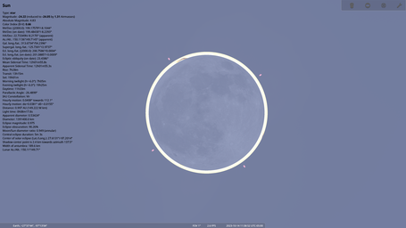
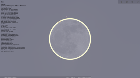
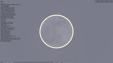
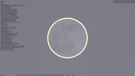
<gallery heights="256px" widths="455px"> | |||
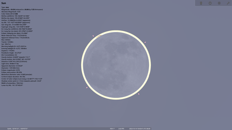
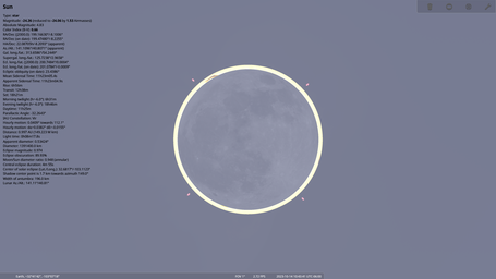
2023-10-14 Annular Solar Eclipse Maximum (Chianti Park).png | Chianti Park, Rio Rancho, NM | |||
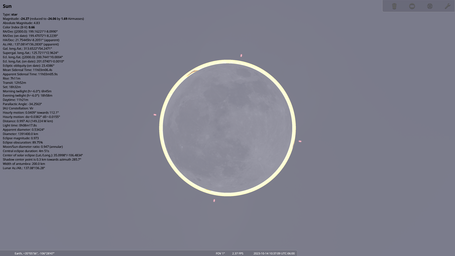
2023-10-14 Annular Solar Eclipse Maximum (Star Heights Park).png | Star Heights Park, Rio Rancho, NM | |||
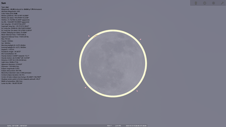
2023-10-14 Annular Solar Eclipse Maximum (Chaco Culture National Historical Park).png | Chaco Culture National Historical Park, Nageezi, NM | |||
</gallery> | |||
=== tier-one locations === | |||
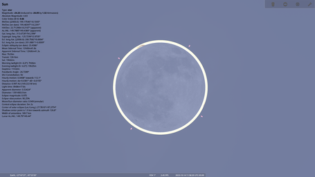
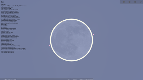
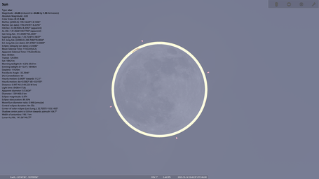
<gallery heights="256px" widths="455px"> | |||
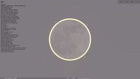
2023-10-14 Annular Solar Eclipse Maximum (King Soccerplex).png | King Soccerplex, Hobbs, NM | |||
2023-10-14 Annular Solar Eclipse Maximum (Jefferson Elementary School).png | Jefferson Elementary School, Hobbs, NM | |||
2023-10-14 Annular Solar Eclipse Maximum (Embudo Trailhead).png | Embudo Trailhead, Albuquerque, NM | |||
2023-10-14 Annular Solar Eclipse Maximum (Sugar Park).png | Sugar Park, Rio Rancho, NM | |||
2023-10-14 Annular Solar Eclipse Maximum (Oak Creek Campground).png | Oak Creek Campground, Richfield, UT | |||
</gallery> | |||
=== tier-two locations === | |||
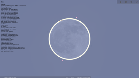
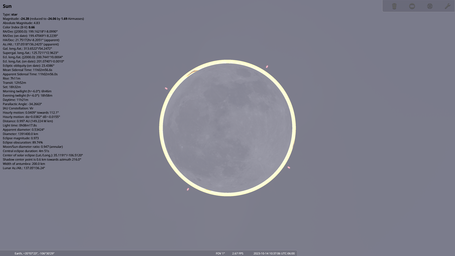
<gallery heights="256px" widths="455px"> | |||
2023-10-14 Annular Solar Eclipse Maximum (Packery Channel Oak Motte Sanctuary).png | Packery Channel Oak Motte Sanctuary, Corpus Christi, TX | |||
2023-10-14 Annular Solar Eclipse Maximum (Packery Channel Nature Park).png | Packery Channel Nature Park, Corpus Christi, TX | |||
2023-10-14 Annular Solar Eclipse Maximum (Sarnia Park).png | Sarnia Park, Corpus Christi, TX | |||
2023-10-14 Annular Solar Eclipse Maximum (Sherrill Park).png | Sherrill Park, Corpus Christi, TX | |||
2023-10-14 Annular Solar Eclipse Maximum (Artesian Park).png | Artesian Park, Corpus Christi, TX | |||
2023-10-14 Annular Solar Eclipse Maximum (Spohn Park).png | Spohn Park, Corpus Christi, TX | |||
2023-10-14 Annular Solar Eclipse Maximum (Humble Park).png | Humble Park, Hobbs, NM | |||
2023-10-14 Annular Solar Eclipse Maximum (Three Gun Trailhead).png | Three Gun Trailhead, Albuquerque, NM | |||
2023-10-14 Annular Solar Eclipse Maximum (Menaul Trailhead).png | Menaul Trailhead, Albuquerque, NM | |||
2023-10-14 Annular Solar Eclipse Maximum (Haynes Park).png | Haynes Park, Rio Rancho, NM | |||
2023-10-14 Annular Solar Eclipse Maximum (Chaco Observatory).png | Chaco Observatory, Nageezi, NM | |||
</gallery> | |||
=== tier-three locations === | |||
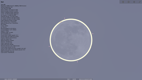
<gallery heights="256px" widths="455px"> | |||
2023-10-14 Annular Solar Eclipse Maximum (Upper Broadway Park).png | Upper Broadway Park, Corpus Christi, TX | |||
2023-10-14 Annular Solar Eclipse Maximum (Washington Park).png | Washington Park, Hobbs, NM | |||
2023-10-14 Annular Solar Eclipse Maximum (Bensing Park).png | Bensing Park, Hobbs, NM | |||
2023-10-14 Annular Solar Eclipse Maximum (Holiday Park).png | Holiday Park, Albuquerque, NM | |||
2023-10-14 Annular Solar Eclipse Maximum (Cabezon Park).png | Cabezon Park, Rio Rancho, NM | |||
2023-10-14 Annular Solar Eclipse Maximum (Western Winds Park).png | Western Winds Park, Rio Rancho, NM | |||
</gallery> | |||
== see also == | == see also == | ||
* <u class="plainlinks"><code>https://www.nicolesharp.net/ | * <u class="plainlinks"><code>https://www.nicolesharp.net/eclipse/2023-10-14.htm</code></u> | ||
* <u><code>[[Solar Eclipse | * <u><code>[[2023-10-14 Solar Eclipse/single-site ephemerides]]</code></u> | ||
* <u><code>[[ | * <u><code>[[2023-10-14 Solar Eclipse/multi-site ephemerides]]</code></u> | ||
* <u><code>[[ | * <u><code>[[2023-10-14 Solar Eclipse/coordinates]]</code></u> | ||
* <u><code>[[2023-10-14 Solar Eclipse]]</code></u> | |||
== references == | |||
<references /> | |||
== keywords == | == keywords == | ||
<code>2023, 2023-10, 2023-10-14, annular, annularity, eclipse, Luna, Lunar, Moon, Sol, Solar, Sun</code> | <code>2023, 2023-10, 2023-10-14, annular, annularity, eclipse, eclipse-chasing, Luna, Lunar, Moon, NM, Sol, Solar, Sun, TX, umbraphilia, US, USA, US-NM, US-TX, US-UT, UT</code> | ||
{{#seo:|keywords=2023, 2023-10, 2023-10-14, annular, annularity, eclipse, Luna, Lunar, Moon, Sol, Solar, Sun}} | {{#seo:|keywords=2023, 2023-10, 2023-10-14, annular, annularity, eclipse, eclipse-chasing, Luna, Lunar, Moon, NM, Sol, Solar, Sun, TX, umbraphilia, US, USA, US-NM, US-TX, US-UT, UT}} | ||
[[category:calendar]] | |||
[[category:astronomy]] | [[category:astronomy]] | ||
[[category:pages with images]] | |||
Latest revision as of 2023-09-29T10:51:57

To observe the Annular Solar Eclipse of 2023-10-14 in the United States of America (USA), you want to be as far east as possible on the Path of Annularity in order to have the highest possible altitude angle at the time of eclipse maximum. However, you also need to be in a location with clear (or mostly clear) skies and no (or very little) wind. Corpus Christi (Texas) is the eastern terminus of the eclipse path in the USA but the weather in October for coastal Texas may not be favorable, which means getting further inland. [2] [3] [4] [5] [6] The next stop west along the eclipse centerline after Corpus Christi (Texas) is Hobbs (New Mexico).
A major difference between a Total Solar Eclipse or Partial Solar Eclipse and an Annular Solar Eclipse is that in order to properly witness Solar annularity, you must be as close as possible to the eclipse centerline and not simply anywhere inside the eclipse path. Any deviation from the eclipse centerline will cause Luna to appear off-axis and thus will not form a true Solar annulus. Whereas during Solar totality, your geographic position inside the eclipse path determines the duration of totality but does not significantly affect the appearance of totality, unlike for annularity during an Annular Solar Eclipse. This makes observing an Annular Solar Eclipse much more challenging than a Total Solar Eclipse since the number of available eclipse observation sites within the eclipse path is proportional to the square of the desired distance from the eclipse centerline.
Additional considerations are that you need an unobstructed field of view in the direction of Sol (such as no buildings or trees in the way) and you will get a clearer view if there is vegetation or water in the azimuth direction of Sol (not sand, pavement, or buildings). A Solar telescope should always be set up on grass (not pavement) if possible. Ideally you want to avoid any urban areas since this can degrade seeing quality. Your parking space should also be close enough to the observation site so that you have a direct line of sight between your telescope and your vehicle.
weather
10-day weather forecasts
- 10-Day Weather Forecast for Corpus Christi, Texas
- 10-Day Weather Forecast for Hobbs, New Mexico
- 10-Day Weather Forecast for Albuquerque, New Mexico
- 10-Day Weather Forecast for Rio Rancho, New Mexico
- 10-Day Weather Forecast for Nageezi, New Mexico
- 10-Day Weather Forecast for Richfield, Utah
hourly weather forecasts
- Hourly Weather Forecast for Corpus Christi, Texas
- Hourly Weather Forecast for Hobbs, New Mexico
- Hourly Weather Forecast for Albuquerque, New Mexico
- Hourly Weather Forecast for Rio Rancho, New Mexico
- Hourly Weather Forecast for Nageezi, New Mexico
- Hourly Weather Forecast for Richfield, Utah
list
Locations listed here are within 2−16 of a Terran mean circumference (0.6108 kilometers, 0.3795 miles, 668 yards, or 2004 feet) from the eclipse centerline which should provide the best possible Solar annulus. [7] All locations in Texas and New Mexico are listed, plus one additional location in Utah. Locations are sorted by default from east to west in longitude, with no locations listed west of the easternmost location in Utah.
Click here to view the eclipse centerline with Google Maps.
Locations within 2−17 of a Terran mean circumference (0.3054 kilometers, 0.1898 miles, 334 yards, or 1002 feet) from the eclipse centerline are listed in bold (19 locations), locations within 2−18 of a Terran mean circumference (0.1527 kilometers, 0.09489 miles, 167 yards, or 501 feet) from the eclipse centerline are listed in bold underline (8 locations), and locations within 2−19 of a Terran mean circumference (0.07635 kilometers, 0.04744 miles, 83.5 yards, or 250.5 feet) from the eclipse centerline are listed in bold double underline (3 locations).
The data provided here is intended as a general guideline only and may contain errors. These locations were identified based on remote imagery from Google Maps and other than from the information that I can find available on the World Wide Web, I have no idea if they still exist or are publicly accessible. [8] You should have multiple locations selected in advance, scout the locations in person the day before the eclipse, and allow yourself enough time on the morning of the eclipse to change locations if necessary.
Remember that you should use GPS (Global Positioning System) coordinates to find observing sites and not rely on street addresses, especially since many parks and wilderness areas may have a postal address that is far away from the actual location. Addresses given in italics should definitely not be used for directions.
If you think that any locations should be removed from or added to this list, please let me know. If you have actually visited any of these locations in person, I would love to get any feedback about their accessibility and usability for the Annular Solar Eclipse.
Latitudes and longitudes were identified using Google Maps in combination with Occult from the International Occultation Timing Association (IOTA). Elevations are from the USGS (USA Geological Survey) Elevation Point Query Service. [9] Eclipse start times, times of eclipse maximum, eclipse end times, eclipse magnitudes ("mag"), and altitude angles at maximum eclipse (expressed as airmasses ["air"]) are from IOTA Occult. [10] Average cloudiness (cl.) for October 14, average windspeed for October (expressed on the Beaufort wind force [B] scale), average air temperature (te.) for October, and average air pressure (pr.) for October are from Time and Date Aksjeselskap. [11]
Times are given in the local timezone (T) for each location.
| location | address | latitude | longitude | elevation | start | max | end | T | mag | air | cl. | B | te. | pr. |
|---|---|---|---|---|---|---|---|---|---|---|---|---|---|---|
| Packery Channel Oak Motte Sanctuary | 14220 S. Padre Island Dr., Corpus Christi, TX 78404 | 27.629106993352558
|
-97.21791448668667
|
1.373965740 m | 10:26:51 | 11:58:52 | 13:38:55 | -5
|
0.975 | 1.3 | 54% | 2.9 | 24°C | 1016 mb |
| Packery Channel Nature Park | 14218 Park Rd. 22, Corpus Christi, TX 78418 | 27.626424227586060
|
-97.22124179592429
|
2.296695232 m | 10:26:51 | 11:58:52 | 13:38:55 | -5
|
0.975 | 1.3 | 54% | 2.9 | 24°C | 1016 mb |
| Sarnia Park | 400A N. Shoreline Dr., Corpus Christi, TX 78401 | 27.792924914534540
|
-97.38837591377255
|
1.483780622 m | 10:26:30 | 11:58:21 | 13:38:16 | -5
|
0.975 | 1.3 | 54% | 2.9 | 24°C | 1016 mb |
| Sherrill Park | 222 S. Shoreline Dr., Corpus Christi, TX 78401 | 27.791001004482155
|
-97.39255437129611
|
4.194799900 m | 10:26:30 | 11:58:20 | 13:38:16 | -5
|
0.975 | 1.3 | 54% | 2.9 | 24°C | 1016 mb |
| Artesian Park | 813 N. Chapparral St., Corpus Christi, TX 78401 | 27.799406697068680
|
-97.39475811576810
|
1.426463366 m | 10:26:29 | 11:58:19 | 13:38:15 | -5
|
0.975 | 1.3 | 54% | 2.9 | 24°C | 1016 mb |
| Spohn Park | 213 N. Mesquite St., Corpus Christi, TX 78401 | 27.794126148686153
|
-97.39597399238578
|
3.241936207 m | 10:26:30 | 11:58:20 | 13:38:15 | -5
|
0.975 | 1.3 | 54% | 2.9 | 24°C | 1016 mb |
| Upper Broadway Park | 901 Leopard St., Corpus Christi, TX 78401 | 27.795710095997112
|
-97.40023169807303
|
9.774136543 m | 10:26:29 | 11:58:19 | 13:38:15 | -5
|
0.975 | 1.3 | 58% | 2.9 | 24°C | 1016 mb |
| Washington Park | 520 S. Fourth St., Hobbs, NM 88240 | 32.695132402803730
|
-103.12189621057546
|
1098.750366211 m | 09:17:09 | 10:43:41 | 12:18:57 | -6
|
0.974 | 1.5 | 32% | 3.1 | 17°C | 1016 mb |
| King Soccerplex | 1409 S. Dal Paso St., Hobbs, NM 88240 | 32.689280029909156
|
-103.12532471201577
|
1098.384399414 m | 09:17:09 | 10:43:41 | 12:18:57 | -6
|
0.974 | 1.5 | 32% | 3.1 | 17°C | 1016 mb |
| Humble Park | 820 N. Grimes St., Hobbs, NM 88240 | 32.708390997363520
|
-103.14422018415978
|
1108.691162109 m | 09:17:07 | 10:43:38 | 12:18:53 | -6
|
0.974 | 1.5 | 32% | 3.1 | 17°C | 1016 mb |
| Jefferson Elementary School | 1200 W. Park, Hobbs, NM 88240 | 32.707276046843940
|
-103.14919783054361
|
1109.793945313 m | 09:17:07 | 10:43:38 | 12:18:52 | -6
|
0.974 | 1.5 | 32% | 3.1 | 17°C | 1016 mb |
| Bensing Park | 1401 W. Clinton St., Hobbs, NM 88240 | 32.707339411317975
|
-103.15193967651592
|
1110.165893555 m | 09:17:07 | 10:43:37 | 12:18:52 | -6
|
0.974 | 1.5 | 32% | 3.1 | 17°C | 1016 mb |
| Three Gun Trailhead | 35.076468878467640
|
-106.44417450199971
|
1927.192138672 m | 09:13:23 | 10:37:13 | 12:09:49 | -6
|
0.974 | 1.7 | 26% | 1.8 | 15°C | 1015 mb | |
| Embudo Trailhead | 35.099015280469736
|
-106.47977064544932
|
1883.783081055 m | 09:13:21 | 10:37:09 | 12:09:43 | -6
|
0.974 | 1.7 | 26% | 1.8 | 15°C | 1015 mb | |
| Menaul Trailhead | 35.104931742101790
|
-106.48832607476871
|
1826.338378906 m | 09:13:21 | 10:37:09 | 12:09:42 | -6
|
0.974 | 1.7 | 27% | 1.8 | 15°C | 1015 mb | |
| Holiday Park | 11710 Comanche Rd. NE, Albuquerque, NM 87111 | 35.123171939684750
|
-106.50832103164810
|
1746.963500977 m | 09:13:20 | 10:37:06 | 12:09:39 | -6
|
0.974 | 1.7 | 26% | 1.8 | 15°C | 1015 mb |
| Haynes Park | 2006 Grande Blvd. SE, Rio Rancho, NM 87144 | 35.222059979304080
|
-106.66316591794453
|
1595.085327148 m | 09:13:11 | 10:36:51 | 12:09:16 | -6
|
0.974 | 1.7 | 24% | 1.8 | 15°C | 1015 mb |
| Chianti Park | 1210 Chianti Rd. SE, Rio Rancho, NM 87144 | 35.232948599933830
|
-106.68123588833546
|
1617.083740234 m | 09:13:10 | 10:36:49 | 12:09:13 | -6
|
0.974 | 1.7 | 24% | 1.8 | 15°C | 1015 mb |
| Cabezon Park | 2305 Cabezon Blvd. SE, Rio Rancho, NM 87144 | 35.231706034043285
|
-106.68944544040455
|
1617.995361328 m | 09:13:10 | 10:36:48 | 12:09:12 | -6
|
0.974 | 1.7 | 24% | 1.8 | 15°C | 1015 mb |
| Western Winds Park | 2260 Zaragoza Rd. SE, Rio Rancho, NM 87144 | 35.245321265835486
|
-106.69098172286776
|
1650.114257813 m | 09:13:09 | 10:36:48 | 12:09:11 | -6
|
0.974 | 1.7 | 24% | 1.8 | 15°C | 1015 mb |
| Star Heights Park | 800 Polaris Blvd. SE, Rio Rancho, NM 87144 | 35.246861788085420
|
-106.70309738645146
|
1669.708618164 m | 09:13:09 | 10:36:47 | 12:09:10 | -6
|
0.974 | 1.7 | 25% | 1.8 | 15°C | 1015 mb |
| Sugar Park | 500 Sugar Rd. NE, Rio Rancho, NM 87144 | 35.252347780215445
|
-106.70916693777448
|
1698.502319336 m | 09:13:08 | 10:36:46 | 12:09:09 | -6
|
0.974 | 1.7 | 25% | 1.8 | 15°C | 1015 mb |
| Chaco Culture National Historical Park | 36.030512129387496
|
-107.90517899441724
|
1889.114013672 m | 09:12:03 | 10:34:46 | 12:06:13 | -6
|
0.973 | 1.7 | 25% | 1.8 | 12°C | 1018 mb | |
| Chaco Observatory | 36.030829365470126
|
-107.90993560556717
|
1889.400634766 m | 09:12:03 | 10:34:46 | 12:06:12 | -6
|
0.973 | 1.7 | 25% | 1.8 | 12°C | 1018 mb | |
| Oak Creek Campground | 38.089781474967140
|
-111.34180986801425
|
2703.356201172 m | 09:09:28 | 10:29:46 | 11:58:36 | -6
|
0.973 | 2.0 | 32% | 1.8 | 11°C | 1017 mb |
Note that there are very confusingly two different campgrounds at Fishlake National Forest both named "Oak Creek Campground". Always use the GPS coordinates and don't get these mixed up.
distances
Travel times and driving distances by car from Cumberland, Maryland. Data is from Microsoft MapPoint 2013.
| time | distance | location | city | state |
|---|---|---|---|---|
| 23:12 h | 1605.9 mi. | Artesian Park | Corpus Christi | Texas |
| 23:13 h | 1606.2 mi. | Spohn Park | Corpus Christi | Texas |
| 23:14 h | 1606.4 mi. | Upper Broadway Park | Corpus Christi | Texas |
| 23:16 h | 1607.0 mi. | Sherrill Park | Corpus Christi | Texas |
| 23:17 h | 1606.9 mi. | Sarnia Park | Corpus Christi | Texas |
| 23:30 h | 1626.3 mi. | Packery Channel Nature Park | Corpus Christi | Texas |
| 23:33 h | 1626.6 mi. | Packery Channel Oak Motte Sanctuary | Corpus Christi | Texas |
| 24:00 h | 1670.5 mi. | Washington Park | Hobbs | New Mexico |
| 24:00 h | 1670.7 mi. | King Soccerplex | Hobbs | New Mexico |
| 24:01 h | 1671.4 mi. | Humble Park | Hobbs | New Mexico |
| 24:03 h | 1672.1 mi. | Jefferson Elementary School | Hobbs | New Mexico |
| 24:04 h | 1671.8 mi. | Bensing Park | Hobbs | New Mexico |
| 24:50 h | 1711.2 mi. | Three Gun Trailhead | Albuquerque | New Mexico |
| 24:52 h | 1716.6 mi. | Embudo Trailhead | Albuquerque | New Mexico |
| 24:52 h | 1717.1 mi. | Menaul Trailhead | Albuquerque | New Mexico |
| 24:53 h | 1718.3 mi. | Holiday Park | Albuquerque | New Mexico |
| 25:08 h | 1735.1 mi. | Haynes Park | Rio Rancho | New Mexico |
| 25:14 h | 1737.1 mi. | Chianti Park | Rio Rancho | New Mexico |
| 25:15 h | 1737.9 mi. | Cabezon Park | Rio Rancho | New Mexico |
| 25:15 h | 1738.1 mi. | Western Winds Park | Rio Rancho | New Mexico |
| 25:17 h | 1738.9 mi. | Star Heights Park | Rio Rancho | New Mexico |
| 25:18 h | 1739.5 mi. | Sugar Park | Rio Rancho | New Mexico |
| 28:19 h | 1872.7 mi. | Chaco Culture National Historical Park | Nageezi | New Mexico |
| 28:20 h | 1873.0 mi. | Chaco Observatory | Nageezi | New Mexico |
| 29:00 h | 1988.8 mi. | Oak Creek Campground | Richfield | Utah |
map
.png)
galleries
tier-zero locations

Chianti Park, Rio Rancho, NM

Star Heights Park, Rio Rancho, NM

Chaco Culture National Historical Park, Nageezi, NM
.png)
.png)
.png)
tier-one locations
King Soccerplex, Hobbs, NM

Jefferson Elementary School, Hobbs, NM
Embudo Trailhead, Albuquerque, NM
Sugar Park, Rio Rancho, NM
Oak Creek Campground, Richfield, UT
.png)
.png)
.png)
.png)
.png)
tier-two locations
Packery Channel Oak Motte Sanctuary, Corpus Christi, TX

Packery Channel Nature Park, Corpus Christi, TX

Sarnia Park, Corpus Christi, TX
Sherrill Park, Corpus Christi, TX

Artesian Park, Corpus Christi, TX
Spohn Park, Corpus Christi, TX
Humble Park, Hobbs, NM
Three Gun Trailhead, Albuquerque, NM
Menaul Trailhead, Albuquerque, NM

Haynes Park, Rio Rancho, NM
Chaco Observatory, Nageezi, NM
.png)
.png)
.png)
.png)
.png)
.png)
.png)
.png)
.png)
.png)
.png)
tier-three locations
Upper Broadway Park, Corpus Christi, TX
Washington Park, Hobbs, NM
Bensing Park, Hobbs, NM
Holiday Park, Albuquerque, NM
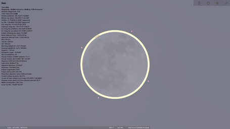
Cabezon Park, Rio Rancho, NM

Western Winds Park, Rio Rancho, NM
.png)
.png)
.png)
.png)
.png)
.png)
see also
https://www.nicolesharp.net/eclipse/2023-10-14.htm2023-10-14 Solar Eclipse/single-site ephemerides2023-10-14 Solar Eclipse/multi-site ephemerides2023-10-14 Solar Eclipse/coordinates2023-10-14 Solar Eclipse
references
- ↑
commons:category:Solar eclipse of 2023 October 14 - ↑
https://www.nicolesharp.net/eclipse/2023-10-14.htm - ↑
https://www.occultations.org/observing/software/occult/ - ↑
https://www.timeanddate.com/ - ↑
https://www.timeanddate.com/eclipse/solar/2023-october-14 - ↑
https://www.timeanddate.com/eclipse/in/usa/corpus-christi?iso=20231014 - ↑
Terran mean circumference - ↑
https://www.googlemaps.com/ - ↑
https://apps.nationalmap.gov/epqs/ - ↑
wikipedia:airmass - ↑
wikipedia:Beaufort number
keywords
2023, 2023-10, 2023-10-14, annular, annularity, eclipse, eclipse-chasing, Luna, Lunar, Moon, NM, Sol, Solar, Sun, TX, umbraphilia, US, USA, US-NM, US-TX, US-UT, UT